GIS APPLICATIONS IN TRAFFIC ENGINEERING, KPR Institute Engineering and Technology, Autonomous Engineering Institution, Coimbatore, India

All
UG Courses

Offline (Outside the campus)
GIS APPLICATIONS IN TRAFFIC ENGINEERING
Webinar Dept. Level
DATE
Aug 18, 2022
TIME
11:00 AM to 12:00 PM
LOCATION
-
DEPARTMENT
Civil Engineering
TOTAL PARTICIPATES
57
Outcome
1. Participants able to get basic knowledge about the applications of GIS in traffic
2. Participants able to measure the distances using Google earth software
3. Participants able to design the road alignment using Q-GIS software
Summary
The Department of Civil Engineering of KPRIET conducted webinar on "GIS Applications in Traffic Engineering" on . The main aim of this webinar is to make the students to aware about the applications of GIS in traffic engineering stream. Dr.A.Gandhimathi Associate Professor of Civil Engineering department from KCT, Coimbatore had given a speech on the uses of GIS mapping and its outcomes for viewing the simulation methods in Traffic Engineering. Also, she explained about the real time information modelling on bus stops and provided sample distance calculation using "Google Earth" software for both students and faculties from various departments. The program was conducted through google meet.
She explained the following contents during the webinar:
1. Highway Accident analysis: CCTV in most cities and towns, as well as satellites imaging services, is easy to integrate with GIS. Location addressing is used to raise the alarm to accident emergency responders to offer help. GIS can act as a source of a report in the event of an accident.
2. Traffic modelling: Most cities in the world are full of vehicles. Failure by the government to effectively manage traffic leads to heavy congestion and traffic jams, which are difficult to keep up with. Following the significant changes being made in the world of computer technology, most countries are migrating to the use of computer systems for traffic management and structure design. GIS has offered great solutions on traffic management for the different vast road networks available in cities and towns. This has proved to ease congestion by as only the best designs of road, rail and air are constructed. GIS does not only monitor these transport systems during construction but also offers surveillance and visualization of traffic after they are built.
3. Route planning: When a proposal is made to construct new roads or railway lines, field experts must approve the routes on which the developments are to be laid out. Longer routes are to add more resource consuming and make travel time to increase, for example with roads and railways drastically. Road and rail engineers must navigate road or rail routes via the shortest and most efficient paths. Longer routes deprive the citizen or user of the road money as much of the expenses go on fuel costs. Efficient, secure, and shorter paths must, therefore, be realized. Its, however difficult to determine the best route if manual methods are used. GIS is best to apply in such instances as drainage, soil properties, and the sloppiness of land is easy to determine. This is thus one of the commonly performed tasks by GIS on infrastructure. It`s also easier to come with route designs and models when using GIS.
4. Environmental Impact Assessment: Roads, railways, ports, and airports are usually built on the land. The existence of some structures that are put along with transportation amenities may have consequences on human life or that of wildlife. A good example is the construction of a highway or railway across a game park or very near to a water body. The environment is thus a factor that must be considered as it offers the habitat for both human beings and other living organisms. GIS comes to offer help as predictions on what would happen if a given infrastructure is started in a specific location are expounded. Pipelines are sometimes viewed as a mode of transport for petroleum products. Leakages from pipelines cause the death of aquatic animals. Transportation of petroleum and its products through pipelines is thus also another task undertaken with proper integration of GIS as the environment would suffer the most in case some things went wrong.
5. Construction Management: During the construction of airports, structure simulations must be performed using GIS related software before actual construction. Three dimension pictures are part of the design and modeling process. During construction, drone technology can be integrated with GIS to help in visualizing ongoing construction. Errors can then be corrected, and a wide of land properties feed into GIS for further planning. GIS is also used to enable the creation of design templates that explain a prospective project like a highway, airport, or port.
6. Transport safety management: Information from different transport structures is beneficial to help formulate regulations and inform the public on how to use certain transport facilities. Crossing points can have integration with GIS for better signaling of drivers and people trying to crossroads or even railway crossing points. Places considered to be black spots and prone to accidents are also studied using GIS to determine the causes of accidents. This is thus very beneficial to any country.


***END***


Still wondering where to begin?
Apply Now

21st Century Engineering College in Coimbatore

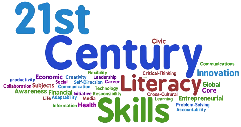
World is transforming everyday. In the rapidly evolving engineering landscape, we have an Increased responsibility to transform the engineering education from traditional curriculum to meet the 21st century skills like Creativity, Critical Thinking, Collaboration and Communication. Through our unique and strategic approach we enable our students to learn beyond and prepare them for life long success.

21st Century Engineering College